Welcome To Hike Los Padres!
User Log In or Sign Up
Use Marker Cluster
Markers: Use Marker Groups
Time used: ms
Routes
    Trails
    OHV Trails
    Forest Roads
    Streams
Wildfire Layers
    Wolf 2002
    Piru 2003
    Day 2006
    Zaca 2007
    Gap 2008
    La Brea 2009
Forest Layers
    Forest Boundary
    Wilderness Areas
    Ranger Districts
    Counties
    Topographic Outlines
    Trailheads
    OHV Trailheads
Helpful Hints
    ↣ Right click the map for location data. ↣ Click a stream for Water Stats.

Middle Matilija Camp South Los Padres National Forest

  • Camp Type: Wilderness Trail Camp
  • Topo Map Link: Wheeler Springs
  • Elevation: 2323 feet
  • Wilderness Area: Matilija
  • County: Ventura County
  • Ranger District: Ojai Ranger District
  • Longitude: -119.3507693
  • Latitude: 34.52875982
  • Water Sources: Always water in the nearby Matilija Creek
  • Length of Stay: 14 Days
  • Reservations: Wilderness Trail Camp

Recent Water Reports:

Date Surveyor Water Report
07-14-2024AndyFlowing
06-24-2022Kiki MFlowing
06-12-2022Anonymous SurveyorFlowing
05-21-2022TJ WaltonFlowing
03-19-2022Jon BainFlowing
01-16-2022Anonymous SurveyorFlowing
11-06-2021Patrick P LeibachFlowing
06-30-2021TFFlowing
05-08-2021Sam C. Flowing
04-19-2021Ryan FreemanFlowing
03-21-2021Davide BisiFlowing
03-03-2021Daniel J. HallFlowing
01-17-2021Anonymous BackpackerFlowing
07-17-2020Anonymous SurveyorFlowing
02-17-2020Jesse RodriguezFlowing
12-29-2019Christopher P. LordFlowing
12-29-2019Antonio CalderonFlowing
02-16-2019Los Padres Forest AssociationFlowing
11-10-2018Mark Hibberd (Troop 179)Flowing
11-11-2017Oh ThreeFlowing
03-04-2017Craig R. CareyFlowing
02-13-2017Anonymous SurveyorFlowing
02-12-2017Bryant K.Flowing
01-28-2017TaliaFlowing
01-16-2017Anonymous SurveyorFlowing
11-11-2016Jasonn BeckstrandFlowing
10-17-2016Anonymous SurveyorFlowing
08-15-2016Anonymous SurveyorDry
01-17-2016Shaddus Maximus Flowing
01-09-2016Craig R. CareyFlowing
11-28-2015TrailseekerFlowing
08-29-2015Anonymous SurveyorFlowing
07-18-2015David LeoncavalloFlowing
12-23-2014Anonymous SurveyorFlowing
11-09-2014Los Padres Forest AssociationFlowing
10-28-2014Los Padres Forest AssociationFlowing
10-04-2014Los Padres Forest AssociationFlowing
08-17-2014Los Padres Forest AssociationFlowing

Photo By: Christopher P Lord - Website Link
Upload Image
Survey This Camp

Description:

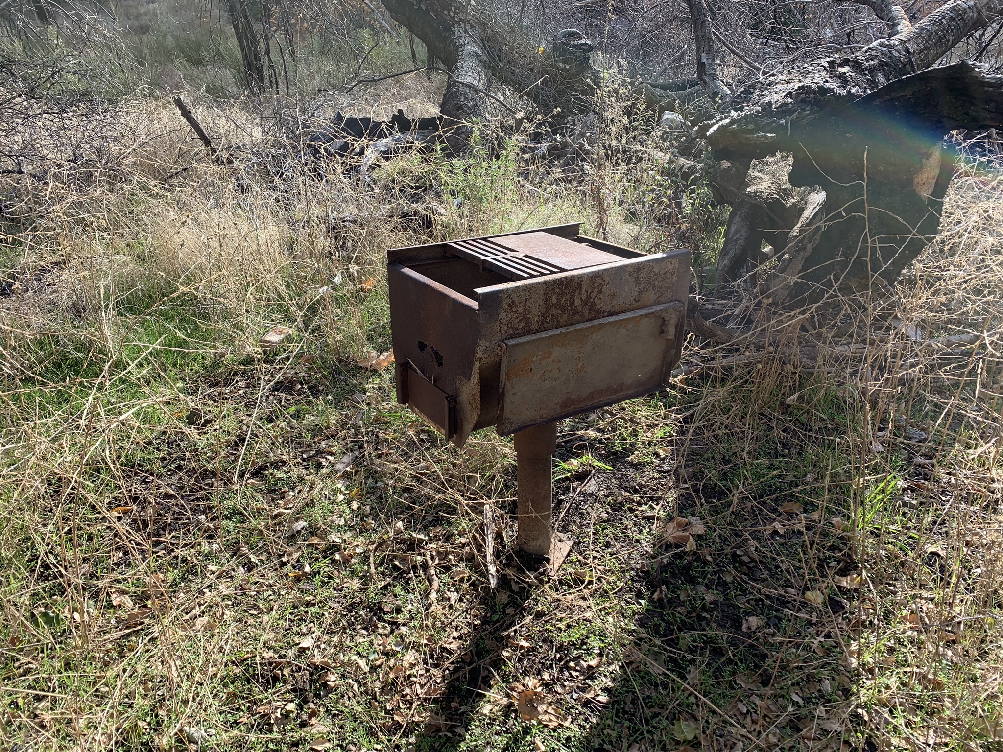
Middle Matilija is a popular camp located up the Matilija Canyon Trail.  The camp has multiple sites, each with a raised BBQ grill and is just above the very reliable Matilija Creek.  This site is frequented by both dayhikers and backpackers and is a regular stop amongst scouting troops in the area.  The trail gets noticably worse above this camp.

Recent Uploads:
Survey Photos:


  • Los Padres Forest Association - 10-28-2014

  • Los Padres Forest Association - 11-09-2014
  • David Leoncavallo - 07-18-2015

  • Craig R. Carey - 01-09-2016

  • Craig R. Carey - 01-09-2016

  • Jasonn Beckstrand - 11-11-2016

  • Talia - 01-28-2017
    Creek right down the path from camp had ample water but was a little murky

  • Talia - 01-28-2017
    Wanted to follow the trail across the creek to Upper Matilija camp but there was a rock slide from the recent rains and the trail looked steep and super narrow.

  • Bryant K. - 02-12-2017

  • Bryant K. - 02-12-2017

  • Bryant K. - 02-12-2017

  • Bryant K. - 02-12-2017

  • Anonymous Surveyor - 02-13-2017
    My Campsite...

  • Craig R. Carey - 03-04-2017

  • Craig R. Carey - 03-04-2017

  • Oh Three - 11-11-2017

  • Los Padres Forest Association - 02-16-2019
    Downed tree and hollowed tree waiting to join its friend on the ground

  • Christopher P. Lord - 12-29-2019
    Lower site

  • Christopher P. Lord - 12-29-2019
    Lower site

  • Christopher P. Lord - 12-29-2019
    Lower site

  • Christopher P. Lord - 12-29-2019
    Middle Matilija

  • Christopher P. Lord - 12-29-2019
    Middle Matilija

  • Christopher P. Lord - 12-29-2019
    Middle Matilija

  • Antonio Calderon - 12-29-2019
    Middle matilija

  • Antonio Calderon - 12-29-2019
    Lower site

  • Anonymous Backpacker - 01-17-2021
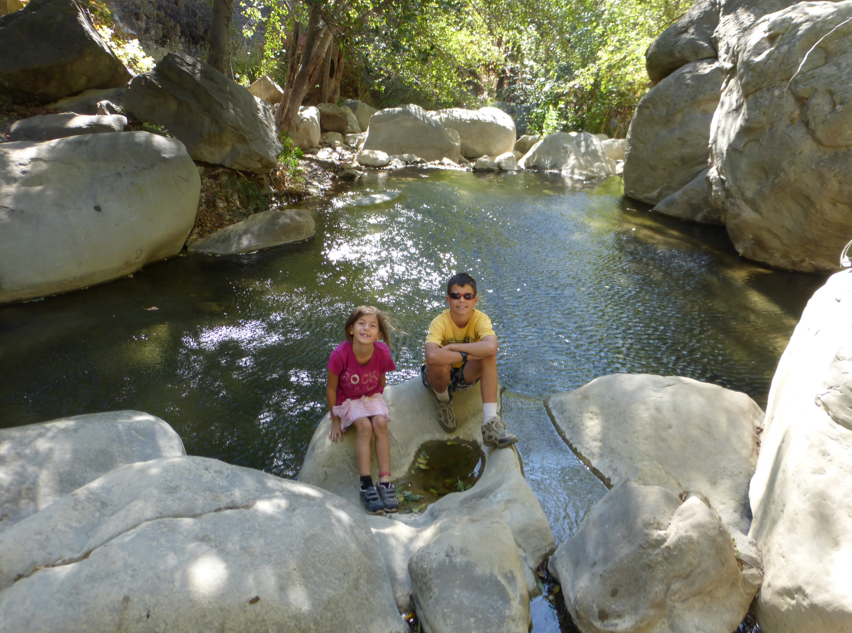
    One of the pools along the river, with our dog taking a bath!

  • Anonymous Backpacker - 01-17-2021
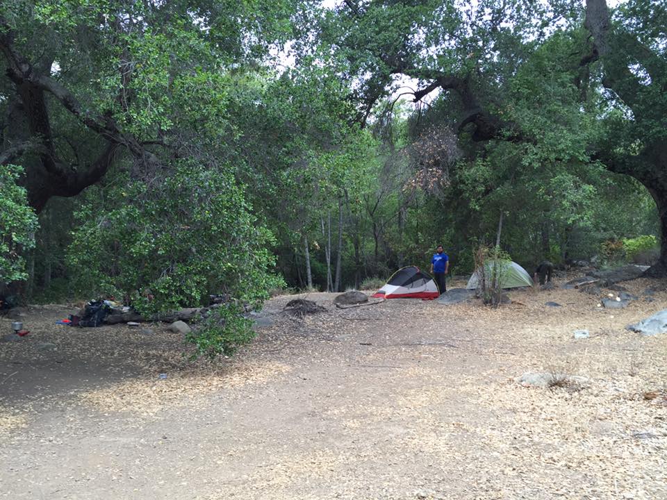
    The campground

  • Ryan Freeman - 04-19-2021
    Fallen Oak Tree

  • Sam C. - 05-08-2021
    A section of creek immediately adjacent to camp. Water flow is strong.

  • Sam C. - 05-08-2021
    A view of camp with the fire pit to our backs and looking towards the creek.

  • Sam C. - 05-08-2021
    One of the deeper pools about 50ish yards upstream from camp.

  • Sam C. - 05-08-2021
    Fire ring fully intact and some nice logs set up for seating.

  • Sam C. - 05-08-2021
    About a half mile or so past Middle Matilija -- some great mini falls and deep pools!

Submitted Camp Reports

Middle Matilija Camp Survey - 07-14-2024 - by Andy
Link: Middle Matilija Camp
Date: 07-14-2024
Surveyor Name:Andy
Camp Description:Great spot for visiting the pools and waterfalls. We could not locate the steel firebox, and there is a lot of low brush that would need to be stamped down before setting a tent. 
Water Source:Flowing
Water Source Details:Creek flow was deep and clear
Weather Conditions:
Middle Matilija Camp Survey - 06-24-2022 - by Kiki M
Link: Middle Matilija Camp
Date: 06-24-2022
Surveyor Name:Kiki M
Camp Description:Would advise to filter water while the creek is flowing during the day or at the first Matilija camp.
Water Source:Flowing
Water Source Details:The creek was flowing during the day, but very low trickle at night.
Weather Conditions:high 80s during the day
Middle Matilija Camp Survey - 06-12-2022 - by Anonymous Surveyor
Link: Middle Matilija Camp
Date: 06-12-2022
Surveyor Name:Anonymous Surveyor
Camp Description:
Water Source:Flowing
Water Source Details:Good flow. Water temperature was unexpectedly not very cool, on the warm side.
Weather Conditions:
Middle Matilija Camp Survey - 05-21-2022 - by TJ Walton
Link: Middle Matilija Camp
Date: 05-21-2022
Surveyor Name:TJ Walton
Camp Description:We only made it to the first camp you come across just after the switchbacks. The big fire ring is still there, and it works great. Same as the log, and there's a little stone table as well. Plenty of dead wood around. Caution is advised on the switchbacks leading into middle Matilija; at some parts the path is narrow and a little unstable on the cliff-edge.
Water Source:Flowing
Water Source Details:Water was a good 4-6 feet wide at the crossing just before the first campsite, was clear and readily filterable.
Weather Conditions:Clear skies, 80+ degrees 73-ish feel with breeze
Middle Matilija Camp Survey - 03-19-2022 - by Jon Bain
Link: Middle Matilija Camp
Date: 03-19-2022
Surveyor Name:Jon Bain
Camp Description:Both upper and lower camps were clean and fire pits in working order.  

BBQ pole has rusted out and the main BBQ is just on the ground now.  

There was a baby rattlesnake coiled up by the hollowed oak at the upper site.  

We had a group of 6 at the upper site, probably room for a few more. A small group of hikers cowboy camped at the lower middle site, and I think there was a group at the secret camp before Middle (at 3 mile before stream and switchbacks).  We met another pair who tried (and failed) to reach Upper Matijila. 

 The night we stayed, we had a light rain, and then very high winds in the night.  

Water Source:Flowing
Water Source Details:Good flow in creek.
Weather Conditions:65F say, 45 F night. Rained briefly around 4. Wind gusts very strong after 3am.
Middle Matilija Camp Survey - 01-16-2022 - by Anonymous Surveyor
Link: Middle Matilija Camp
Date: 01-16-2022
Surveyor Name:Anonymous Surveyor
Camp Description:Way less buggy than expected and very pleasant day and nighttime temperatures (68F/40F).
Water Source:Flowing
Water Source Details:
Weather Conditions:
Middle Matilija Camp Survey - 11-06-2021 - by Patrick P Leibach
Link: Middle Matilija Camp
Date: 11-06-2021
Surveyor Name:Patrick P Leibach
Camp Description:Camp is in rough shape.  At second (upper) site, stove is knocked down and unusable (irrelevant in this case given fire restrictions).  Fire ring would be usable for cooking.  Lots of dead limbs on the trees overhanging the camp, would be careful setting up tent on a windy night.  Black flies were very rough til after sunset, bring bug dope.  Missed the first (lower) site on hike up where lost the trail for a bit (this happened a lot after mile 2; trail needs work but works because can just follow creek when you lose trail), passed through lower camp on way out.  A bunch of left-behind gear in crook of a tree, appears someone's been squatting there at some recent point.  That all said, enjoyed ourselves thoroughly, hike in showed interesting cross sections of up-thrust sedimentary layers especially around mile 3 where trail goes up river-left and canyon narrows a bit before the trail sign.  Lots of inviting swimming holes even with low flow.  Several unofficial campsites miles 2.5-3.5 looked good in addition to the "official" Middle Matilija.  "Critical" information above is not a critique but FYI for anyone planning a trip.  
Water Source:Flowing
Water Source Details:Steady flow ~2CFS, clear and cold
Weather Conditions:Sunny and clear, ranging 35-75.
Middle Matilija Camp Survey - 06-30-2021 - by TF
Link: Middle Matilija Camp
Date: 06-30-2021
Surveyor Name:TF
Camp Description:
Water Source:Flowing
Water Source Details:
Weather Conditions:
Middle Matilija Camp Survey - 05-08-2021 - by Sam C.
Link: Middle Matilija Camp
Date: 05-08-2021
Surveyor Name:Sam C.
Camp Description:Camp is in wonderful condition and water was flowing fast. The area is clear and has lots of level spots for pitching multiple tents. The fire pit is fully intact with some logs/boulders set up for seating. There were multiple pools that ran alongside camp which were deep enough for soaking in. About a half mile or so past camp there are some more really awesome water falls and deep pools for playing in as well. We had originally trekked through to Upper Matilija -- once you get past the falls/pools and switchbacks, the trail becomes pretty impossible to follow and requires a lot of bushwhacking. Upper Matilija is not so much a camp at this point -- lots of fallen trees and overgrown grasses. We couldn't see the remains of the fire pit, but think it was hidden by brush/downed trees. We ended up backtracking to Middle Matilija, which is by far the nicest camp we passed through. Wouldn't recommend the effort to get out to Upper Matilija at this point.
Water Source:Flowing
Water Source Details:Water was flowing fast and super clear!
Weather Conditions:High: 78, Low: 50
Images:

A section of creek immediately adjacent to camp. Water flow is strong.

A view of camp with the fire pit to our backs and looking towards the creek.


One of the deeper pools about 50ish yards upstream from camp.

Fire ring fully intact and some nice logs set up for seating.


About a half mile or so past Middle Matilija -- some great mini falls and deep pools!
Middle Matilija Camp Survey - 04-19-2021 - by Ryan Freeman
Link: Middle Matilija Camp
Date: 04-19-2021
Surveyor Name:Ryan Freeman
Camp Description:Day hiked here from Matilija Camp, took about an hour and half. The creek is very close with a good flow. A couple of big oak trees provide most of the shade. There is a fallen oak tree which could be used to hammock camp. Nice rock ring for fire located in middle of camp. Much quieter camp from day hikers. You could fit about 8 people here comfortably. 
Water Source:Flowing
Water Source Details:Good flow
Weather Conditions:Sunny and breezy, 88 degrees high, 50 degrees low
Images:

Fallen Oak Tree
Middle Matilija Camp Survey - 03-21-2021 - by Davide Bisi
Link: Middle Matilija Camp
Date: 03-21-2021
Surveyor Name:Davide Bisi
Camp Description:The camp was in good conditions, sheltered by beautiful oaks. Highly recommended backpacking destination.
Water Source:Flowing
Water Source Details:
Weather Conditions:Clear and windy
Middle Matilija Camp Survey - 03-03-2021 - by Daniel J. Hall
Link: Middle Matilija Camp
Date: 03-03-2021
Surveyor Name:Daniel J. Hall
Camp Description:Nice camp in good shape, except for the big old oaks that have become "hazard trees" which have fallen or will fall in the camping area.  Need to be careful where you pitch your tent if there is a high wind.  For more detail in captioned photos, see https://tinyurl.com/yd3fk56m
Water Source:Flowing
Water Source Details:Good flow of clear water, but low for this time of year.
Weather Conditions:
Middle Matilija Camp Survey - 01-17-2021 - by Anonymous Backpacker
Link: Middle Matilija Camp
Date: 01-17-2021
Surveyor Name:Anonymous Backpacker
Camp Description:Large campground with nearby creek. Not the most attractive spot on the trail, but good enough.
Water Source:Flowing
Water Source Details:Decent amount of water and lots of pools
Weather Conditions:Incredibly warm for this time of the year, temperatures in the 80s
Images:

One of the pools along the river, with our dog taking a bath!

The campground
Middle Matilija Camp Survey - 07-17-2020 - by Anonymous Surveyor
Link: Middle Matilija Camp
Date: 07-17-2020
Surveyor Name:Anonymous Surveyor
Camp Description:
Water Source:Flowing
Water Source Details:
Weather Conditions:
Middle Matilija Camp Survey - 02-17-2020 - by Jesse Rodriguez
Link: Middle Matilija Camp
Date: 02-17-2020
Surveyor Name:Jesse Rodriguez
Camp Description:
Water Source:Flowing
Water Source Details:
Weather Conditions:
Middle Matilija Camp Survey - 12-29-2019 - by Christopher P. Lord
Link: Middle Matilija Camp
Date: 12-29-2019
Surveyor Name:Christopher P. Lord
Camp Description:Hiked up to Middle Matilija Camp Sunday 12/29/19 from the Matilija Trailhead. 23W07 is in fine condition until just before reaching the newer lower Campsite. N34° 31' 39.3" W119° 21' 06.9"  lower Camp has nice spacious flat here with plenty of seating and a large rock fire ring. Appears this lower site is now getting most of the use. Around the creek bend the original site still has an old winged stove and primitive fire ring. N34° 31' 43.6" W119° 21' 03.7" Water is plentiful. The trail leading up and beyond the Camp is a mess. Washed out overgrown and hard to follow. More details can be found at the link below:
Water Source:Flowing
Water Source Details:
Weather Conditions:Chilly 50's storm was coming in
Images:

Lower site

Lower site


Lower site

Middle Matilija


Middle Matilija
Middle Matilija Camp Survey - 12-29-2019 - by Antonio Calderon
Link: Middle Matilija Camp
Date: 12-29-2019
Surveyor Name:Antonio Calderon
Camp Description:Nice day hike destination. Looks like the main site got taken over by a down tree. A much nicer site is just a short walk downstream with big fire ring and spacious area. 
Water Source:Flowing
Water Source Details: Cold with good flow
Weather Conditions:Cloudy in the low 50s
Images:

Middle matilija

Lower site
Middle Matilija Camp Survey - 02-16-2019 - by Los Padres Forest Association
Link: Middle Matilija Camp
Date: 02-16-2019
Surveyor Name:Los Padres Forest Association
Camp Description:Middle Matilija is also in need of some love.  A downed tree has removed some of the upper portion of the camp and a standing hollow oak is threatening to fall across more of the camp (choose your site wisely).  The camp BBQ stands are toppled.  Looks like it just went through a wildfire followed by two huge storms - oh wait, it did.

The trail heading upstream is clearly define now thanks to BAER work.
Water Source:Flowing
Water Source Details:Knee deep at the crossing below camp
Weather Conditions:Cool, breezy, sunny
Images:

Downed tree and hollowed tree waiting to join its friend on the ground
Middle Matilija Camp Survey - 11-10-2018 - by Mark Hibberd (Troop 179)
Link: Middle Matilija Camp
Date: 11-10-2018
Surveyor Name:Mark Hibberd (Troop 179)
Camp Description:

Camp site is no longer the wonderful place it once was. Still ok, but most oaks burned during Thomas Fire and toppled over by flooding last Winter. Trail washed out upstream.  Still some shade from remaining oaks and flat spots for sleeping. The area is very different now, but still beautiful.

Water Source:Flowing
Water Source Details:Clean clear stream with good flow.
Weather Conditions:
Middle Matilija Camp Survey - 11-11-2017 - by Oh Three
Link: Middle Matilija Camp
Date: 11-11-2017
Surveyor Name:Oh Three
Camp Description:
Large Camp. No end of water. 

We took a long break here. It's probably not far enough away from the south end to avoid the crowds. If you want solitude, stick  to Upper or Maple. But with a little bad weather, or, obviously, mid-week, you'll likely have this beautiful camp to yourself.

And there's 3 giant oaks here that must date back to, I don't know, way back!
Water Source:Flowing
Water Source Details:
Weather Conditions:
Images:

Middle Matilija Camp Survey - 03-04-2017 - by Craig R. Carey
Link: Middle Matilija Camp
Date: 03-04-2017
Surveyor Name:Craig R. Carey
Camp Description:The intrepid mountain men of Boy Scout Troop 111 (Ventura) backpacked the length of the Upper North Fork (from Cherry Creek Road at Hwy 33 to lower Matilija TH) Friday 3/3 to Sunday 3/5.

Spent second night of our trek at Middle Matilija. Camp's in great shape though the steep drop into camp from the north is gullied from recent storms. Poison oak coming back with a vengeance along little bluff above creek.

Great water.
Water Source:Flowing
Water Source Details:Fast and clear!
Weather Conditions:Cool and high clouds; rain began as we packed out.
Images:


Middle Matilija Camp Survey - 02-13-2017 - by Anonymous Surveyor
Link: Middle Matilija Camp
Date: 02-13-2017
Surveyor Name:Anonymous Surveyor
Camp Description:First solo trip and first time camping in Los Padres. Camp was generally clean apart from a little trash in the fire pits. Stayed at the first campsite when approaching the campground from south since it looked a little more tidy and there were a lot of ants around the other fire pit. Water flowing rapidly but murky. Not much firewood probably due to Bryant K. being there the night before (haha)... I mostly took remnants from around and in the other fire pit. Temps in the low 40s at night. Encountered some ticks in the area so check yourself if going through bushes.
Water Source:Flowing
Water Source Details:Flowing rapidly; murky
Weather Conditions:Sunny and partly cloudy at times. Low 40s at night.
Images:

My Campsite...
Middle Matilija Camp Survey - 02-12-2017 - by Bryant K.
Link: Middle Matilija Camp
Date: 02-12-2017
Surveyor Name:Bryant K.
Camp Description:Trail was in pretty good condition even after the heavy rain the day prior. Trail was a little grown over at times and with poison oak creep in sections, but in great condition for the most part. Camp had an abundance of wood in its various desirable forms to have a nice fire. Up stream from the camp the trail required a little bush whacking, but still easily hikeable. Experienced strong gusts around 3 am, but tempature never got lower than 48 degrees.
Water Source:Flowing
Water Source Details:Water was flowing great. A bit murky so you may want to bring your blackflow tool if you have a Sawyer Mini
Weather Conditions:Very pleasant with the right layers.
Images:


Middle Matilija Camp Survey - 01-28-2017 - by Talia
Link: Middle Matilija Camp
Date: 01-28-2017
Surveyor Name:Talia
Camp Description:1st time hiking this trail. We backpacked to Middle Matilija camp and I counted a total of 10 creek crossings from the trailhead to camp. Some areas with poison oak but as long as you wear long pants you'll be fine. Trail was easy to follow and not too overgrown. Lots of shade along the trail. 
Water Source:Flowing
Water Source Details:Creek was flowing and full of water.
Weather Conditions:70s during the day, high 30s to low 40s at night
Images:

Creek right down the path from camp had ample water but was a little murky

Wanted to follow the trail across the creek to Upper Matilija camp but there was a rock slide from the recent rains and the trail looked steep and super narrow.
Middle Matilija Camp Survey - 01-16-2017 - by Anonymous Surveyor
Link: Middle Matilija Camp
Date: 01-16-2017
Surveyor Name:Anonymous Surveyor
Camp Description:
Water Source:Flowing
Water Source Details:Flowing nicely with several pools
Weather Conditions:Mild and sunny!
Middle Matilija Camp Survey - 11-11-2016 - by Jasonn Beckstrand
Link: Middle Matilija Camp
Date: 11-11-2016
Surveyor Name:Jasonn Beckstrand
Camp Description:
Water Source:Flowing
Water Source Details:good clean water at the camp. Nice pools to dunk in below the camp
Weather Conditions:72 no wind perfect hiking
Images:

Middle Matilija Camp Survey - 10-17-2016 - by Anonymous Surveyor
Link: Middle Matilija Camp
Date: 10-17-2016
Surveyor Name:Anonymous Surveyor
Camp Description:
Water Source:Flowing
Water Source Details:plenty of water flow. camp in great shape
Weather Conditions:
Middle Matilija Camp Survey - 08-15-2016 - by Anonymous Surveyor
Link: Middle Matilija Camp
Date: 08-15-2016
Surveyor Name:Anonymous Surveyor
Camp Description:
Water Source:Dry
Water Source Details:I may have missed the main source for this camp. There's water flowing above and below the camp.
Weather Conditions:
Middle Matilija Camp Survey - 01-17-2016 - by Shaddus Maximus
Link: Middle Matilija Camp
Date: 01-17-2016
Surveyor Name:Shaddus Maximus
Camp Description:
Water Source:Flowing
Water Source Details:
Weather Conditions:
Middle Matilija Camp Survey - 01-09-2016 - by Craig R. Carey
Link: Middle Matilija Camp
Date: 01-09-2016
Surveyor Name:Craig R. Carey
Camp Description:The Cubs of Pack 3179 had a great (soggy) hike from Matilija TH to Middle Matilija, with an extended rock-hopping break at Matilija camp. Camp in good shape after the rains, good water.
Water Source:Flowing
Water Source Details:
Weather Conditions:High 40s, drizzle.
Images:


Middle Matilija Camp Survey - 11-28-2015 - by Trailseeker
Link: Middle Matilija Camp
Date: 11-28-2015
Surveyor Name:Trailseeker
Camp Description:Poison oak has seemed to be dying down, but is still there. 
Water Source:Flowing
Water Source Details:The stream running by camp provides plenty of water for filtering/cooking, but not enough for swimming.
Weather Conditions:Partly cloudy with light sprinkling. Low 32F, High 69F
Middle Matilija Camp Survey - 08-29-2015 - by Anonymous Surveyor
Link: Middle Matilija Camp
Date: 08-29-2015
Surveyor Name:Anonymous Surveyor
Camp Description:Beware poison oak, it's pretty much everywhere. 
Water Source:Flowing
Water Source Details:Plenty of water collecting in little pools right below the campsite; makes for easy filtering. Not enough for swimming/soaking.
Weather Conditions:
Middle Matilija Camp Survey - 07-18-2015 - by David Leoncavallo
Link: Middle Matilija Camp
Date: 07-18-2015
Surveyor Name:David Leoncavallo
Camp Description:The campsite is in good condition, and there is enough space for 4 or 5 two person tents.  Shady enough to stay cool in the summer.
Water Source:Flowing
Water Source Details:Plenty of water for camping, not enough for swimming.
Weather Conditions:
Images:

Middle Matilija Camp Survey - 12-23-2014 - by Anonymous Surveyor
Link: Middle Matilija Camp
Date: 12-23-2014
Surveyor Name:Anonymous Surveyor
Camp Description:"Water, water, everywhere......"
Water Source:Flowing
Water Source Details:
Weather Conditions:
Middle Matilija Camp Survey - 11-09-2014 - by Los Padres Forest Association
Link: Middle Matilija Camp
Date: 11-09-2014
Surveyor Name:Los Padres Forest Association
Camp Description:
Water Source:Flowing
Water Source Details:
Weather Conditions:
Images:

Middle Matilija Camp Survey - 10-28-2014 - by Los Padres Forest Association
Link: Middle Matilija Camp
Date: 10-28-2014
Surveyor Name:Los Padres Forest Association
Camp Description:Water flowing and pools deep enough for some wading action.  This canyon is old reliable when everything else is dry - at least so far......
Water Source:Flowing
Water Source Details:
Weather Conditions:
Images:

Middle Matilija Camp Survey - 10-04-2014 - by Los Padres Forest Association
Link: Middle Matilija Camp
Date: 10-04-2014
Surveyor Name:Los Padres Forest Association
Camp Description:Information from Ojai Ranger District
Water Source:Flowing
Water Source Details:
Weather Conditions:
Middle Matilija Camp Survey - 08-17-2014 - by Los Padres Forest Association
Link: Middle Matilija Camp
Date: 08-17-2014
Surveyor Name:Los Padres Forest Association
Camp Description:Trail report from Scout Troop 33
Water Source:Flowing
Water Source Details:
Weather Conditions:

Leave A Camp Report

Survey / Report Form


Last Updated: Monday, January 4, 2016

Join Our Mailing List
×
Get updates on conditions, surveys and more...

L.P.N.F. Contacts »

  • Forest Headquarters
    Phone: (805) 968-6640
  • Mt. Pinos District
    Phone: (661) 245-3731
  • Ojai Ranger District
    Phone: (805) 646-4348
  • Santa Barbara District
    Phone: (805) 967-3481
  • Santa Lucia District
    Phone: (805) 925-9538
  • Monterey District
    Phone: (831) 385-5434