 Use Marker Groups
 Wolf 2002
Piru 2003
Day 2006
Zaca 2007
Gap 2008
La Brea 2009

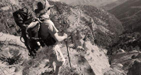
1,257 Miles of Trails on 1,762,400 Acres, with 875,000 Acres of Protected Wilderness to Explore.
Thank you for taking the time to visit the Hike Los Padres Community. This website was created with the mission of being a source of shared information on trails, camps, and locations across the entire Northern and Southern portions of the Los Padres National Forest. The more information we all share and catalog, the better we can track the conditions of the forest network and figure out what sections, trails, and locations are safe to use and which need maintenance.
A good portion of the interior of Los Padres National Forest gets very little use by the public, so any information on these areas will ensure that these places remain accessible for future generations of hikers, backpackers, trail runners, equestrians, O.H.V, hunters, cyclists, and explorers. Many of the trails listed may be unmaintained. Know your level of ability, and always remember to bring extra water.
In partnership with the Los Padres Forest Association (LPFA). The LPFA’s mission is to care for the Los Padres Forest, ensuring it thrives and remains safe and open for the people to use and enjoy. LPFA volunteers work to keep trails open, report and assess forest conditions and provide public education on how to use the forest safely. If you are interested in becoming a member or volunteering, please visit www.lpforest.org to learn more.
Location specific weather reports, recent camp and trail surveys, water data and much more.
 Los Prietos Campground Mt Pinos Campground Chula Vista Campground Manzana Schoolhouse Camp Arroyo Seco Campground
  Ballinger Route 52 OHV… Ballinger Route 23 OHV… Ballinger Route 9 OHV… Ballinger Route 53 OHV… Horseshoe Springs Spur…
 Wheeler Resi - Forest… Los Prietos - Forest… Piano Box L Ohv - Forest… Sierra Madre - Forest… Pine Canyon - Forest…
 | Location | Date ▾ | Surveyor | Water Report |
|---|---|---|---|
| Sykes Hot Springs | 10-1-1996 | Los Padres Forest Association | Flowing |
| Mono Campground | 1-1-2024 | Los Padres Forest Association | Flowing |
| Llly Meadows Camp | 06-01-2025 | Anonymous Surveyor | Trickle |
| Ant Camp | 05-29-2025 | Holden | Flowing |
| Matias Potrero Camp | 05-26-2025 | Shaddus Maximus | Dry |
| Beartrap Camp | 05-26-2025 | Anonymous Surveyor | Flowing |
| Fishbowls Camp | 05-25-2025 | LC | Flowing |
| Lower Camuesa Camp | 05-25-2025 | Shaddus Maximus | Dry |
| East Fork Lion Camp | 05-25-2025 | Omar Eff | Flowing |
| Middle Lion Campground | 05-25-2025 | Omar Eff | Flowing |
| 19 or Nineteen Oaks Camp | 05-24-2025 | Shaddus Maximus | Flowing |
| Middle Camuesa Camp | 05-24-2025 | Shaddus Maximus | Dry |
| Madulce Camp | 05-24-2025 | Brad Marston | Flowing |
| Coldwater Camp | 05-24-2025 | Jen Smith | Flowing |
| Cottam Camp | 05-23-2025 | Dylan T | Trickle |
| Valley View Camp | 05-22-2025 | Diane Soini | Flowing |
| Lady Bug Camp | 05-22-2025 | Diane Soini | Dry |
| Upper Bear Camp | 05-19-2025 | Anonymous Surveyor | Flowing |
| Forbush Camp | 05-17-2025 | Casey Hall | Flowing |
| Mono Campground | 05-17-2025 | Casey Hall | Flowing |
| Lady Bug Camp | 05-17-2025 | Dusty Ham | Flowing |
| Oak Camp | 05-16-2025 | Michael Carter | Flowing |
| Mission Pine Basin Camp | 05-15-2025 | Dalton Beeler | Dry |
| Cedar Creek Camp | 05-11-2025 | Laura Clay | Flowing |
| Fishbowls Camp | 05-10-2025 | Dylan Belitski | Flowing |
| Happy Hunting Ground Camp | 05-04-2025 | Luna | Flowing |
| White Ledge Camp - San Rafael Wilderness | 05-03-2025 | Luna | Flowing |
| Three Mile Camp | 05-01-2025 | Anonymous Surveyor | Flowing |
| Pine Mountain Lodge Camp | 05-01-2025 | Anonymous Surveyor | Flowing |
| Haddock Camp | 04-30-2025 | Anonymous Surveyor | Flowing |
| Beartrap Camp | 04-30-2025 | Anonymous Surveyor | Flowing |
| Upper Reyes Camp | 04-30-2025 | Anonymous Surveyor | Flowing |
| Chorro Grande Camp | 04-28-2025 | Anonymous Surveyor | Trickle |
| White Ledge Camp - Red Reef Trail | 04-27-2025 | Anonymous Surveyor | Flowing |
| Oak Flat Camp | 04-26-2025 | Zach Teske | Flowing |
| Willet Camp | 04-25-2025 | Zach Teske | Flowing |
| Matias Potrero Camp | 04-19-2025 | Brian King | Dry |
| Mansfield Camp | 04-19-2025 | Randy Lahey | Flowing |
| South Fork Camp - Sisquoc | 04-19-2025 | Randy Lahey | Flowing |
| Pine Mountain Lodge Camp | 04-18-2025 | Brandon Steets | Flowing |
| Fishbowls Camp | 04-18-2025 | Brandon Steets | Flowing |
| Alcove Camp | 04-18-2025 | Randy Lahey | Trickle |
| Bear Creek Camp | 04-17-2025 | Daniel J. Hall | Flowing |
| Manzana Schoolhouse Camp | 04-15-2025 | BJ | Flowing |
| Estrella Camp | 04-12-2025 | Anonymous Surveyor | Flowing |
| Heath Camp | 04-12-2025 | Antonio Calderon | Flowing |
| South Fork Camp - Sisquoc | 04-12-2025 | Antonio Calderon | Flowing |
| Lady Bug Camp | 04-12-2025 | Tom Kelley | Flowing |
| Gridley Springs Camp | 04-06-2025 | Anonymous Surveyor | Trickle |
| Ant Camp | 04-06-2025 | Rick Hayes | Flowing |
| Painted Rock Camp | 04-06-2025 | Dave Bourgeois | Flowing |
| Oak Camp | 04-03-2025 | Chris Houlberg - Scoutmaster Troop119 | Flowing |
| Cow Spring Camp | 03-30-2025 | Laura Clay | Flowing |
| Valley View Camp | 03-29-2025 | Gio | Flowing |
| 19 or Nineteen Oaks Camp | 03-28-2025 | Jen Smith | Trickle |
| Sheep Camp | 03-27-2025 | Anonymous Surveyor | Flowing |
| Manzana Narrows Camp | 03-24-2025 | Anonymous Surveyor | Flowing |
| Fish Creek Camp | 03-24-2025 | Anonymous Surveyor | Flowing |
| Rays Camp | 03-24-2025 | Anonymous Surveyor | Flowing |
| Manzana Camp | 03-24-2025 | Anonymous Surveyor | Flowing |
Please click on a report below to view the survey
 Sykes Hot Springs Survey - 10-1-1996 - by Los Padres Forest Association
| Link: | Sykes Hot Springs |
| Date: | 10-1-1996 |
| Surveyor Name: | Los Padres Forest Association |
| Camp Description: | A story about a missed chance at visiting Sykes from 1996. Worth a read: https://www.latimes.com/lifestyle/story/2025-03-03/big-sur-wildfire-threat-camping-survival-story-between-a-rock |
| Water Source: | Flowing |
| Water Source Details: | |
| Weather Conditions: |
Mono Campground Survey - 1-1-2024 - by Los Padres Forest Association| Link: | Mono Campground |
| Date: | 1-1-2024 |
| Surveyor Name: | Los Padres Forest Association |
| Camp Description: | Historic video showing the construction of the Mono Debris Dam from 1936, enjoy! https://archive.org/details/CCCAtMono1936 |
| Water Source: | Flowing |
| Water Source Details: | |
| Weather Conditions: |
Llly Meadows Camp Survey - 06-01-2025 - by Anonymous Surveyor| Link: | Llly Meadows Camp |
| Date: | 06-01-2025 |
| Surveyor Name: | Anonymous Surveyor |
| Camp Description: | |
| Water Source: | Trickle |
| Water Source Details: | |
| Weather Conditions: |
Ant Camp Survey - 05-29-2025 - by Holden| Link: | Ant Camp |
| Date: | 05-29-2025 |
| Surveyor Name: | Holden |
| Camp Description: | Did it from Dough Flats, there and back wore shirts and no shirt and carried a 50 pound pack. Mind the trail going up to the saddle, however, it's quite easy to get lost. Tried and failed to get to Saddle Skirt. Will come back one day to get there. There are thousands of feet of irrigation, still in good condition if anyone wants. |
| Water Source: | Flowing |
| Water Source Details: | Good flow and will be at least a trickle for probably the whole summer |
| Weather Conditions: |
Matias Potrero Camp Survey - 05-26-2025 - by Shaddus Maximus| Link: | Matias Potrero Camp |
| Date: | 05-26-2025 |
| Surveyor Name: | Shaddus Maximus |
| Camp Description: | |
| Water Source: | Dry |
| Water Source Details: | Stock up on water either from the Santa Ynez or a side drainage about 1/2 mile west of camp |
| Weather Conditions: |
Beartrap Camp Survey - 05-26-2025 - by Anonymous Surveyor| Link: | Beartrap Camp |
| Date: | 05-26-2025 |
| Surveyor Name: | Anonymous Surveyor |
| Camp Description: | Bear Trap camp was great. Large, lots of shade, lots of room to spread out though we were the only campers. The creek was flowing, the water was cold. We could even see some trout in the deeper pools. We experienced lots of ticks of course, fresh bear scat but a big surprise was a sunbathing rattlesnake on the trail. This made us more aware of the need for trail maintenance as we noticed it was real hard at times to see the trail through the brush. |
| Water Source: | Flowing |
| Water Source Details: | |
| Weather Conditions: | Highs of 80s, lows in the 40s. |
Fishbowls Camp Survey - 05-25-2025 - by LC| Link: | Fishbowls Camp |
| Date: | 05-25-2025 |
| Surveyor Name: | LC |
| Camp Description: | |
| Water Source: | Flowing |
| Water Source Details: | low-ish volume, but good clean flow. |
| Weather Conditions: |
Lower Camuesa Camp Survey - 05-25-2025 - by Shaddus Maximus| Link: | Lower Camuesa Camp |
| Date: | 05-25-2025 |
| Surveyor Name: | Shaddus Maximus |
| Camp Description: | |
| Water Source: | Dry |
| Water Source Details: | Water can be found in the creek about 0.5-1 mile above Lower Camuesa Camp. |
| Weather Conditions: |
East Fork Lion Camp Survey - 05-25-2025 - by Omar Eff| Link: | East Fork Lion Camp |
| Date: | 05-25-2025 |
| Surveyor Name: | Omar Eff |
| Camp Description: | Enjoyed a great overnight trip: two adults, two 10-yo. One of the two fire rings had intact stove. Great flow in the creek. We had lots of fun hiking up the creek to the falls, swimming in the pool beneath and scrambling up the rocks to higher points. Lots of fish (some bigger than 6") in the creek, including adjacent to campsite. Also saw several aquatic garter snakes. The trail between the Four Points Trail Junction and campsite is dense with thorny vegetation and then difficult to follow in dry creek bed. |
| Water Source: | Flowing |
| Water Source Details: | |
| Weather Conditions: | Sunny and warm during the day; not too cold at night |
Middle Lion Campground Survey - 05-25-2025 - by Omar Eff| Link: | Middle Lion Campground |
| Date: | 05-25-2025 |
| Surveyor Name: | Omar Eff |
| Camp Description: | Stopped briefly before and after overnight hike to East Fork Lion Camp. Lots of water in the creek and some nice pools to wade and play in, including up the creek near the first crossing along the Lion Canyon Trail. Sites were full on Sunday night but all emptied out on Monday (holiday). |
| Water Source: | Flowing |
| Water Source Details: | |
| Weather Conditions: | Mostly sunny and warm |
Please click on a report below to view the survey
Bucksnort Trail Survey - 05-29-2025 - by Holden| Link: | Bucksnort Trail |
| Date: | 05-29-2025 |
| Surveyor Name: | Holden |
| Trail description: | Not too hard at all, until you go down the big mountain. Pain in the ass from then on, and the trail is a bit scattered and easy to get lost, especially when coming up again. you'll get kind of cut up but it's too hot to put on a shirt or pants. prepare for 2 hours up or down the last big hill. |
| Mode of transport: | Hike |
| Trail condition: | Hard to follow |
| Condition details: | Great 'til the Saddle |
Santa Barbara Canyon Trail Survey - 05-27-2025 - by Brad Marston| Link: | Santa Barbara Canyon Trail |
| Date: | 05-27-2025 |
| Surveyor Name: | Brad Marston |
| Trail description: | The trail is generally easy to follow, with one exception being a section of about 100' length where it seems to be in the creek due to a slide and fallen trees. From about miles 2.5 to 3.5 from the trailhead brushing is needed. In some parts in that section it is hard to avoid poison oak which mixes in with the wild roses. The new switchbacks are wonderful! Thank you for all the hard work building them. |
| Mode of transport: | Hike |
| Trail condition: | Needs some work |
| Condition details: | brushing needed in parts |
Madulce Trail Survey - 05-27-2025 - by Brad Marston| Link: | Madulce Trail |
| Date: | 05-27-2025 |
| Surveyor Name: | Brad Marston |
| Trail description: | Hiked up about 2 miles from Madulce camp. Very brushy after trail leaves creek to climb the ridge, with whitethorn ceanothus (or similar) jabbing with large needles. Big downed, smooth, and steeply inclined tree blocked our way further (shown in May 2, 2025 report). |
| Mode of transport: | Hike |
| Trail condition: | Needs some work |
| Condition details: | Brushy with large downed tree blocking way |
Lion Canyon Trail Survey - 05-25-2025 - by Omar Eff| Link: | Lion Canyon Trail |
| Date: | 05-25-2025 |
| Surveyor Name: | Omar Eff |
| Trail description: | The trail is generally great condition from Middle Lion Camp, except for dense vegetation immediately at the trailhead and then again in the last section between Four Points Junction and East Fork Camp. Immediately after the fork, there was a jungle of dense vegetation, with lots of thorns, and then the trail was difficult to follow through dry creek bed. |
| Mode of transport: | Hike |
| Trail condition: | Needs some work |
| Condition details: | Clear and easy up until just past the Four Points Junction |
Sespe River Trail Survey - 05-25-2025 - by AidLenSel| Link: | Sespe River Trail |
| Date: | 05-25-2025 |
| Surveyor Name: | AidLenSel |
| Trail description: | Trail is in great shape and easy to follow after the first few river crossings. Just keep an eye out for markers and such. The crossing at Bear Creek Camp was a bit tough to find, but some nearby campers were helpful enough to guide us. Get out there before the water dries up! There are still a few swimmable pools, but it has been a dry winter so I wouldn’t wait. Also, watch out for poison oak by Kerr spring, there’s a whole lot, sometimes coming into the trail. |
| Mode of transport: | Hike |
| Trail condition: | Good shape and easy to follow |
Red Reef Trail Survey - 05-21-2025 - by Diane Soini| Link: | Red Reef Trail |
| Date: | 05-21-2025 |
| Surveyor Name: | Diane Soini |
| Trail description: | Hiked this trail from the ridge down to the Sespe. Overall it is followable but there are places with fallen burned trees and one where I had to take my pack off and crawl underneath. The trail gets brushy at times and is tick heaven. I did not see a Ladybug camp or any place you could camp. I saw no water until where the trail crosses Timber Creek a little above Harris Tunnel. I may have left my pot containing a stove, lighter, spoon and green bandana at the creek on the south side of Harris Tunnel. If anyone finds it and wants to return it, my fist and last name, all one word, at gmail is my email. |
| Mode of transport: | Hike |
| Trail condition: | Needs some work |
| Condition details: | Brushy, ric-rack areas sketchy, saw no camps |
Franklin Trail North Survey - 05-21-2025 - by Diane Soini| Link: | Franklin Trail North |
| Date: | 05-21-2025 |
| Surveyor Name: | Diane Soini |
| Trail description: | I went down to explore the Jameson end of the trail and discovered the old parking area was washed away, the sluice was broken and the start of the trail is not readily apparent. I do not know what the rest of the trail is like but the devastation at the mouth of the canyon doesn't look promising. |
| Mode of transport: | Hike |
| Trail condition: | Needs some work |
| Condition details: | The start of the trail obscured and old parking area washed away |
Chorro Grande Trail Survey - 05-17-2025 - by Casey Horgan| Link: | Chorro Grande Trail |
| Date: | 05-17-2025 |
| Surveyor Name: | Casey Horgan |
| Trail description: | Biked down from Pine Mountain trailhead. Trail was in good shape and easy to follow, but could use brushing and tread work in various locations. |
| Mode of transport: | Bicycle |
| Trail condition: | Needs some work |
Murietta Trail Survey - 05-17-2025 - by Diane Soini| Link: | Murietta Trail |
| Date: | 05-17-2025 |
| Surveyor Name: | Diane Soini |
| Trail description: | I came over Murietta Divide from the Jameson Lake side. The dirt road was washed out in many areas wherever there was a side canyon starting right after the spring. Although I saw a cairn marking the Murietta trail where the upper portion meets the road, I did not have confidence the trail still exists so I did not follow. It did not help that the last trip report here that sounds like anyone went all the way to the road is from 2021. It would be helpful if anyone has hiked the complete trail could let us know if the whole trail is open. |
| Mode of transport: | Hike |
| Trail condition: | Needs some work |
| Condition details: | I did not trust the trail existed |
Santa Barbara Canyon Trail Survey - 05-03-2025 - by Ian Jackson| Link: | Santa Barbara Canyon Trail |
| Date: | 05-03-2025 |
| Surveyor Name: | Ian Jackson |
| Trail description: | Hiked from Madulce down to the trailhead and the trail is in pretty great shape. - The new switchback section on heartbreak hill is amazing with excellent tread and clearance. - Middle section of the trail has some brushy spots but to be expected with how much time it spends along the creek bottom. |
| Mode of transport: | Hike |
| Trail condition: | Good shape and easy to follow |
 Cozy Dell Trail
 Ventana Cone
  Live Oak Spring - Sisquoc