 Use Marker Groups
 Wolf 2002
Piru 2003
Day 2006
Zaca 2007
Gap 2008
La Brea 2009

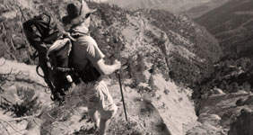
1,257 Miles of Trails on 1,762,400 Acres, with 875,000 Acres of Protected Wilderness to Explore.
Thank you for taking the time to visit the Hike Los Padres Community. This website was created with the mission of being a source of shared information on trails, camps, and locations across the entire Northern and Southern portions of the Los Padres National Forest. The more information we all share and catalog, the better we can track the conditions of the forest network and figure out what sections, trails, and locations are safe to use and which need maintenance.
A good portion of the interior of Los Padres National Forest gets very little use by the public, so any information on these areas will ensure that these places remain accessible for future generations of hikers, backpackers, trail runners, equestrians, O.H.V, hunters, cyclists, and explorers. Many of the trails listed may be unmaintained. Know your level of ability, and always remember to bring extra water.
In partnership with the Los Padres Forest Association (LPFA). The LPFA’s mission is to care for the Los Padres Forest, ensuring it thrives and remains safe and open for the people to use and enjoy. LPFA volunteers work to keep trails open, report and assess forest conditions and provide public education on how to use the forest safely. If you are interested in becoming a member or volunteering, please visit www.lpforest.org to learn more.
Location specific weather reports, recent camp and trail surveys, water data and much more.
 Ballinger Route 19 OHV… Ballinger Route 54 OHV… Ballinger Route 10 OHV… Queen Bee OHV Trail Ballinger Route 49 OHV…
| Location | Date ▾ | Surveyor | Water Report |
|---|---|---|---|
| Sykes Hot Springs | 10-1-1996 | Los Padres Forest Association | Flowing |
| Mono Campground | 1-1-2024 | Los Padres Forest Association | Flowing |
| West Fork Lion Camp | 03-23-2025 | Andy | Flowing |
| Middle Camuesa Camp | 03-21-2025 | Los Padres Forest Association | Dry |
| Log Cabin Camp | 03-16-2025 | Laura Clay | Flowing |
| South Fork Camp - Sisquoc | 03-12-2025 | Paul Costales | Flowing |
| Cottam Camp | 03-08-2025 | Omar Eff | Flowing |
| Piedra Blanca Camp | 03-08-2025 | Jose Fuentes | Flowing |
| Mono Campground | 03-08-2025 | Braulio Aguilera | Flowing |
| Rock Campground | 03-08-2025 | Braulio Aguilera | Flowing |
| Pine Mountain Lodge Camp | 03-07-2025 | Anonymous Surveyor | Flowing |
| Nira Campground | 03-02-2025 | j0nny | Flowing |
| Manzana Narrows Camp | 03-02-2025 | Paul Costales | Flowing |
| Twin Forks Camp | 03-01-2025 | Alex Perry | Flowing |
| Piedra Blanca Camp | 03-01-2025 | Jon Bain | Flowing |
| Llly Meadows Camp | 03-01-2025 | Anonymous Surveyor | Flowing |
| Sheep Camp | 03-01-2025 | Anonymous Surveyor | Flowing |
| Mission Pine Springs Camp | 03-01-2025 | Paul Costales | Flowing |
| Mission Pine Basin Camp | 03-01-2025 | Paul Costales | Trickle |
| Mansfield Camp | 03-01-2025 | Paul Costales | Flowing |
| Cottam Camp | 02-28-2025 | Rob Guzzon | Flowing |
| McKinley Spings Camp | 02-28-2025 | Paul Costales | Trickle |
| McKinley Spings Camp | 02-23-2025 | Anonymous Surveyor | Trickle |
| Hidden Potrero Camp | 02-22-2025 | Antonio Calderon | Dry |
| Santa Cruz Camp | 02-22-2025 | Antonio Calderon | Flowing |
| Gridley Springs Camp | 02-17-2025 | Anonymous Surveyor | Flowing |
| Shady Camp | 02-16-2025 | Shaddus Maximus | Flowing |
| Cove Camp | 02-15-2025 | Shaddus Maximus | Flowing |
| Ant Camp | 02-15-2025 | Shaddus Maximus | Flowing |
| Alder Creek Camp - Ventura | 02-15-2025 | Shaddus Maximus | Flowing |
| Last Chance Camp - Sespe | 02-15-2025 | Antonio Calderon | Flowing |
| Log Cabin Camp | 02-14-2025 | Shaddus Maximus | Flowing |
| Oak Flat Camp | 02-08-2025 | Ol' Marto | Flowing |
| Valle Vista Campground | 02-08-2025 | Antonio Calderon | Dry |
| Blue Canyon Camp | 02-08-2025 | Omar Eff | Flowing |
| Oak Camp | 02-01-2025 | Paul Muhl | Flowing |
| Chorro Grande Camp | 02-01-2025 | Paul Muhl | Trickle |
| Madulce Camp | 01-27-2025 | Los Padres Forest Association | Flowing |
| Coldwater Camp | 01-20-2025 | Paul Muhl | Flowing |
| Potrero Camp | 01-20-2025 | Paul Muhl | Flowing |
| Miller Camp | 01-19-2025 | Paul Muhl | Flowing |
| Mormon Camp | 01-19-2025 | Paul Muhl | Flowing |
| Water Canyon Camp | 01-19-2025 | Paul Muhl | Flowing |
| Manzana Schoolhouse Camp | 01-19-2025 | Paul Muhl | Flowing |
| Beartrap Camp | 01-18-2025 | Troop 26 | Flowing |
| Sycamore Camp | 01-18-2025 | Paul Muhl | Flowing |
| Cliff Camp | 01-18-2025 | Paul Muhl | Flowing |
| Abel Canyon Camp | 01-18-2025 | Paul Muhl | Flowing |
| Nira Campground | 01-17-2025 | Paul Muhl | Flowing |
| Rays Camp | 01-17-2025 | Paul Muhl | Flowing |
| Manzana Camp | 01-17-2025 | Paul Muhl | Flowing |
| Manzana Narrows Camp | 01-17-2025 | Paul Muhl | Flowing |
| Happy Hunting Ground Camp | 01-17-2025 | Paul Muhl | Stagnant |
| White Ledge Camp - San Rafael Wilderness | 01-17-2025 | Paul Muhl | Stagnant |
| Upper Santa Ynez Camp | 01-10-2025 | Rich Scholl | Flowing |
| Murietta Camp | 01-10-2025 | Rich Scholl | Flowing |
| Manzana Schoolhouse Camp | 01-04-2025 | Tom Maccianti | Flowing |
| Forbush Camp | 01-03-2025 | Omar Eff | Flowing |
| Middle Camuesa Camp | 01-03-2025 | Surly One | Stagnant |
| Middle Santa Ynez Campground | 01-03-2025 | Surly One | Flowing |
Please click on a report below to view the survey
 Sykes Hot Springs Survey - 10-1-1996 - by Los Padres Forest Association
| Link: | Sykes Hot Springs |
| Date: | 10-1-1996 |
| Surveyor Name: | Los Padres Forest Association |
| Camp Description: | A story about a missed chance at visiting Sykes from 1996. Worth a read: https://www.latimes.com/lifestyle/story/2025-03-03/big-sur-wildfire-threat-camping-survival-story-between-a-rock |
| Water Source: | Flowing |
| Water Source Details: | |
| Weather Conditions: |
Mono Campground Survey - 1-1-2024 - by Los Padres Forest Association| Link: | Mono Campground |
| Date: | 1-1-2024 |
| Surveyor Name: | Los Padres Forest Association |
| Camp Description: | Historic video showing the construction of the Mono Debris Dam from 1936, enjoy! https://archive.org/details/CCCAtMono1936 |
| Water Source: | Flowing |
| Water Source Details: | |
| Weather Conditions: |
West Fork Lion Camp Survey - 03-23-2025 - by Andy| Link: | West Fork Lion Camp |
| Date: | 03-23-2025 |
| Surveyor Name: | Andy |
| Camp Description: | Both primary and secondary sites have tent space. Primary site is a large clearing with plenty of space for multiple tents, plus a good fire ring. Secondary site is more cramped with space for 2 tents, and the stove is hard to access. Creek running between the sites was great, even saw some fish and frogs. Trail from the West/East Fork intersection to the campsite could use some brushing but was manageable. Trail from campsite to the falls is more difficult, and will leave you going through the creek (not a complaint!). |
| Water Source: | Flowing |
| Water Source Details: | Creek flow was deep and clear |
| Weather Conditions: |
Middle Camuesa Camp Survey - 03-21-2025 - by Los Padres Forest Association| Link: | Middle Camuesa Camp |
| Date: | 03-21-2025 |
| Surveyor Name: | Los Padres Forest Association |
| Camp Description: | Got a report that both the creek and spring were dry at Middle Camuesa |
| Water Source: | Dry |
| Water Source Details: | |
| Weather Conditions: |
Log Cabin Camp Survey - 03-16-2025 - by Laura Clay| Link: | Log Cabin Camp |
| Date: | 03-16-2025 |
| Surveyor Name: | Laura Clay |
| Camp Description: | 3/15-3/16 Pothole trail to Log Cabin Camp, back to parking via Agua Blanca Trail Pothole trail: fairly steep with no shade, but in good condition. Last portion uphill has lots of bushes to push through but trail is mostly defined. Some spots where "trail" splits from visual/gps trail, but all meets up in the end. Log Cabin camp: lots of flat ground and wood for fires (when permitted). Water is NOT close to camp at all, at least closest we could find was walking down to Agua Blanca creek probably .3 miles and uphill on the way back to camp was annoying. Plenty of water right now. Lots of critters in the metal cabin skittering throughout the night, noisy frogs, and lack of any seating for the campfire ring made this a very average but not great campsite. EDIT: looks like maybe we didn't camp at Log Cabin but another campsite prior to where the pothole and Agua Blanca trail meet Agua Blanca trail: We made our way downhill back to the parking area, almost immediately had to get our feet wet which made the decision to walk through the pools in Devil's Gateway (where the canyon walls are high on both sides) easy. Got wet up to about knees. Rest of trail back fairly simple to follow with orange flagging at creek crossings, obvious recent maintenance helped. Some poison oak, but didn't seem too crazy (yet). HOWEVER, our dog was with us and we brushed off 5 ticks plus pulled 6+ more that had bitten. So beware! Last ~2-2.5 miles on dirt then paved road with no shade, a little demoralizing. |
| Water Source: | Flowing |
| Water Source Details: | Closest we could find was Agua Blanca Creek, ~.3 miles from camp and uphill to camp |
| Weather Conditions: |
South Fork Camp - Sisquoc Survey - 03-12-2025 - by Paul Costales| Link: | South Fork Camp - Sisquoc |
| Date: | 03-12-2025 |
| Surveyor Name: | Paul Costales |
| Camp Description: | Had a hard time finding the pit toilet, it is outside the barbed wire area. Head from the cabin/river west towards the trail, take a quick left as if you are gonna head up the Sisquoc trail and it is right there on your right behind some bushes. |
| Water Source: | Flowing |
| Water Source Details: | Flowing River |
| Weather Conditions: |
Cottam Camp Survey - 03-08-2025 - by Omar Eff| Link: | Cottam Camp |
| Date: | 03-08-2025 |
| Surveyor Name: | Omar Eff |
| Camp Description: | |
| Water Source: | Flowing |
| Water Source Details: | Great flow in both creeks |
| Weather Conditions: | 60s during the day, bit of frost overnight |
Piedra Blanca Camp Survey - 03-08-2025 - by Jose Fuentes| Link: | Piedra Blanca Camp |
| Date: | 03-08-2025 |
| Surveyor Name: | Jose Fuentes |
| Camp Description: | |
| Water Source: | Flowing |
| Water Source Details: | |
| Weather Conditions: |
Mono Campground Survey - 03-08-2025 - by Braulio Aguilera| Link: | Mono Campground |
| Date: | 03-08-2025 |
| Surveyor Name: | Braulio Aguilera |
| Camp Description: | The camp is gone. Completely overgrown and buried. The tables were crushed by a tree, the pit toilets have sunken so that only the roof shows. There are some flat spots at the entrance and near the creek along the sand. |
| Water Source: | Flowing |
| Water Source Details: | Great flow from the debris dam |
| Weather Conditions: |
Rock Campground Survey - 03-08-2025 - by Braulio Aguilera| Link: | Rock Campground |
| Date: | 03-08-2025 |
| Surveyor Name: | Braulio Aguilera |
| Camp Description: | Camp is looking good, plenty of space. The hotsprings were also looking good and the water was nice and warm. |
| Water Source: | Flowing |
| Water Source Details: | Good amount of water in the creek and at the dam |
| Weather Conditions: |
Please click on a report below to view the survey
Piedra Blanca Trail Survey - 03-21-2025 - by Daniel J. Hall| Link: | Piedra Blanca Trail |
| Date: | 03-21-2025 |
| Surveyor Name: | Daniel J. Hall |
| Trail description: | We went from Piedra Blanca Trailhead to Pine Mt. Lodge, with 2 nights at Twin Forks, from March 19 -21. The trail from the Trailhead to Twin Forks was clear and easy to follow. The first mile up from Twin Forks was clear and easy to follow, except for a couple of minor rock slides that don't affect hikers, but may cause stock some problems. The following stretch of trail up to PML has been recently worked and was in amazing condition: good tread, very wide clearance with extraordinary water bars that are greatly needed in that steep, remote trail and which I hope do not get destroyed by hikers or stock. However, almost up to PML, there was a section of trail about 200 feet long that is thick, over-your-head brush, but at least it is the kind of brush that you can slip through fairly easily. For more detail, see https://tinyurl.com/2bbxdu3r |
| Mode of transport: | Hike |
| Trail condition: | Needs some work |
Piedra Blanca Trail Survey - 03-16-2025 - by bardley| Link: | Piedra Blanca Trail |
| Date: | 03-16-2025 |
| Surveyor Name: | bardley |
| Trail description: | the purpose of my survey is to relate the current water levels at the beginning of this hike, from the piedra blanca trailhead to the far side of sespe creek at the junction / trailhead of the sespe river trail. the water crossings at lion creek, the sespe creek tributary stock and hiker crossings, and the sespe creek main crossing are all readily passable with deepest water levels at mid-calf. a returning hiker related that the further down the sespe - the deeper the water. at the hot springs = hip deep. no defined trail from the stock/hiker crossing to the main crossing. |
| Mode of transport: | Hike |
| Trail condition: | Non existent |
Big Falls Trail Survey - 03-16-2025 - by DMajor| Link: | Big Falls Trail |
| Date: | 03-16-2025 |
| Surveyor Name: | DMajor |
| Trail description: | Did some trail clearing up to the main waterfall Some challenges crossing the river many times All the poison oak is cut back so good tread amd a clear pathway with just a few blowdowns and easy crossing Newts are out in force, and the falls are roaring No trash, no people on the trail in the afternoon Impressive canyon after a trek to the trailhead |
| Mode of transport: | Hike |
| Trail condition: | Good shape and easy to follow |
Agua Blanca Trail Survey - 03-16-2025 - by Laura Clay| Link: | Agua Blanca Trail |
| Date: | 03-16-2025 |
| Surveyor Name: | Laura Clay |
| Trail description: | 3/15-3/16 Pothole trail to Log Cabin Camp, back to parking via Agua Blanca Trail Pothole trail: fairly steep with no shade, but in good condition. Last portion uphill has lots of bushes to push through but trail is mostly defined. Some spots where "trail" splits from visual/gps trail, but all meets up in the end. Log Cabin camp: lots of flat ground and wood for fires (when permitted). Water is NOT close to camp at all, at least closest we could find was walking down to Agua Blanca creek probably .3 miles and uphill on the way back to camp was annoying. Plenty of water right now. Lots of critters in the metal cabin skittering throughout the night, noisy frogs, and lack of any seating for the campfire ring made this a very average but not great campsite. Agua Blanca trail: We made our way downhill back to the parking area, almost immediately had to get our feet wet which made the decision to walk through the pools in Devil's Gateway (where the canyon walls are high on both sides) easy. Got wet up to about knees. Rest of trail back fairly simple to follow with orange flagging at creek crossings, obvious recent maintenance helped. Some poison oak, but didn't seem too crazy (yet). HOWEVER, our dog was with us and we brushed off 5 ticks plus pulled 6+ more that had bitten. So beware! Last ~2-2.5 miles on dirt then paved road with no shade, a little demoralizing. |
| Mode of transport: | Hike |
| Trail condition: | Good shape and easy to follow |
Pothole Trail Survey - 03-15-2025 - by Laura Clay| Link: | Pothole Trail |
| Date: | 03-15-2025 |
| Surveyor Name: | Laura Clay |
| Trail description: | 3/15-3/16 Pothole trail to Log Cabin Camp, back to parking via Agua Blanca Trail Pothole trail: fairly steep with no shade, but in good condition. Last portion uphill has lots of bushes to push through but trail is mostly defined. Some spots where "trail" splits from visual/gps trail, but all meets up in the end. Log Cabin camp: lots of flat ground and wood for fires (when permitted). Water is NOT close to camp at all, at least closest we could find was walking down to Agua Blanca creek probably .3 miles and uphill on the way back to camp was annoying. Plenty of water right now. Lots of critters in the metal cabin skittering throughout the night, noisy frogs, and lack of any seating for the campfire ring made this a very average but not great campsite. Agua Blanca trail: We made our way downhill back to the parking area, almost immediately had to get our feet wet which made the decision to walk through the pools in Devil's Gateway (where the canyon walls are high on both sides) easy. Got wet up to about knees. Rest of trail back fairly simple to follow with orange flagging at creek crossings, obvious recent maintenance helped. Some poison oak, but didn't seem too crazy (yet). HOWEVER, our dog was with us and we brushed off 5 ticks plus pulled 6+ more that had bitten. So beware! Last ~2-2.5 miles on dirt then paved road with no shade, a little demoralizing. |
| Mode of transport: | Hike |
| Trail condition: | Good shape and easy to follow |
Arroyo Burro Trail South Survey - 03-04-2025 - by Anonymous Surveyor| Link: | Arroyo Burro Trail South |
| Date: | 03-04-2025 |
| Surveyor Name: | Anonymous Surveyor |
| Trail description: | Starting to get some poison oak encroaching on the single track just as you get off the paved road, but otherwise it is in good shape. I only went up to the meadow and back above the sandstone outcroppings, so can't say how the single track trail looks beyond that. All Trails indicates that this is a "closed" trail but I didn't see any signage to that effect at the trailhead. Does anyone know if it is now ok to go all the way up to Camino Cielo (is there an easement through the private property as you get back in there)? |
| Mode of transport: | Hike |
| Trail condition: | Good shape and easy to follow |
Sisquoc Trail Lower Survey - 03-01-2025 - by Paul Costales| Link: | Sisquoc Trail Lower |
| Date: | 03-01-2025 |
| Surveyor Name: | Paul Costales |
| Trail description: | Went downstream from Mansfield to South Fork at night (not recommended). When the trail is away from the river it is pretty easy to follow, with the exception of some downed trees to go around or over. When it comes to river crossings it can be difficult to find where the trail picks up. Especially difficult about 0.5mi to 1.0mi above south fork, where we elected to get our feet wet and follow the creek when we got stuck somehow on the south side of the bank (we may have missed a crossing to the north side). Some reflective USFS signs help at river crossings, and sometimes a cairn or flag, but could use some more markings. |
| Mode of transport: | Hike |
| Trail condition: | Hard to follow |
| Condition details: | Was at night, but downed trees make for some diversions, and creek crossing make finding the other side more difficult |
Blue Canyon Trail Survey - 02-28-2025 - by Rob Guzzon| Link: | Blue Canyon Trail |
| Date: | 02-28-2025 |
| Surveyor Name: | Rob Guzzon |
| Trail description: | Backpacked out to Cottam. Blue Canyon trail from Forbush to Cottam is in pretty good shape, but could use a haircut. One member of the group went for a run east from Cottam and up Romero trail. Section of Blue Canyon trail east of Cottam is more overgrown than west of Cottam, and could use some work. |
| Mode of transport: | Hike |
| Trail condition: | Needs some work |
| Condition details: | Tread in decent shape, could use a haircut |
Piedra Blanca Trail Survey - 02-24-2025 - by Los Padres Forest Association| Link: | Piedra Blanca Trail |
| Date: | 02-24-2025 |
| Surveyor Name: | Los Padres Forest Association |
| Trail description: | LPFA Trail Volunteers just finished up their third multi-day trail maintenance project in the past year to brush the Piedra Blanca Trail from Piedra Blanca Camp to Pine Mountain Lodge Camp. The trail is now brush free until about 200 feet below PML Camp. Thank you volunteers! Check out lpforest.org for volunteer trail maintenance opportunities in the Los Padres.... |
| Mode of transport: | Hike |
| Trail condition: | Needs some work |
Rose Lion Trail Survey - 02-24-2025 - by Los Padres Forest Association| Link: | Rose Lion Trail |
| Date: | 02-24-2025 |
| Surveyor Name: | Los Padres Forest Association |
| Trail description: | LPFA volunteers wrapped up 3 days of brushing this trail over the month of February. The connector should be in great shape! |
| Mode of transport: | Hike |
| Trail condition: | Good shape and easy to follow |
 Little Sur Trail
 Pine Valley Camp
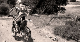
 Lime Canyon - Forest…
  Puerto Del Suelo Peak
  Chokecherry Spring